NORTHWEST MINNESOTA TOURISM DIRECTORY |
|
|
MAJOR
TRAILS (most w/groomed x-cntry
skiing)
EGF Red
River State Rec.
MAPS
SNOWMOBILE TRAIL
NAMES
Wapiti
Trail
Agassiz Trail Riders (Karlstad) Driftbusters (Crookston) Fourtown (Grygla) Moonshiners (Twin Valley) North Star (Thief River Falls) Pathfinders (Red Lake Falls) Polar Beach (McIntosh) Red River (East Grand Forks) Sand Hill Snow Cruisers (Fertile) Sno-Cat Riders, Inc (Warren) Sno-Drifters (Thief River Falls)
MAPS |
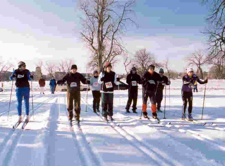
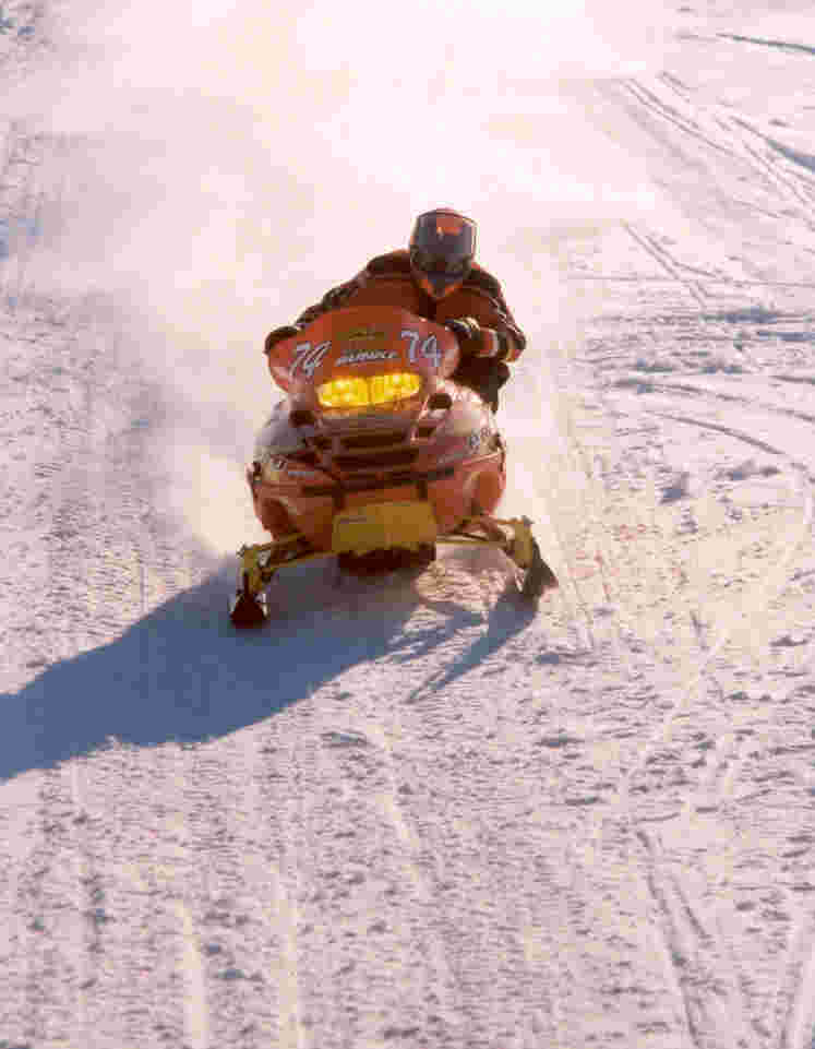
Multi-Purpose Trails Information including Snowmobile Connections Below are lists of trails in our seven county area of Northwest Minnesota. Entries are listed alphabetically by city. Snowmobile and ATV club contact information is included at the bottom of the page. There are hundreds of miles of hiking, biking, horseback riding, and cross country ski trails listed below so get out there and enjoy! Thousands of miles of snowmobile trails are also listed. To include your trail to this list or to update your information e-mail Jennifer Olson. Part of the directory covers snowmobile trails and local club contacts. A page containing a quick, poor quality version of the snowmobile trails map is available or a higher print quality snowmobile trails map is available to download in Acrobat Reader. This is a 531 KB file that may take a long time to view. Major Driving Routes Information Includes information, maps and links on six major driving routes in our region including:
Multi-purpose Trails Information Region and Multi-County Routes King of Trails Scenic Byway Trails - Drive U.S. Highway 75 the King of Trails from Canada to Mexico.
Information -
This trail was previously utilized by Native Americans/settlers and was
designated by the State of Minnesota as "The Historic King of Trails" in
2001. Efforts include an annual marketplace day where communities along
Hwy. 75 invite vendors to openly market their goods at select locations. Minnesota Wildflower Route Trails - Wildflower route along Hwy 11 from Greenbush to Baudette. The route contains up to an estimated 800,000 showy pink ladyslippers, the protected state flower of Minnesota. Information - An annual "Wildflower Route Celebration" is related to this route.
Trails - MOM's Way takes you on a 400 mile route from Winnipeg to Thunder Bay traveling through Minnesota, Ontario and Manitoba Information - Discover a route less taken & experience spectacular scenery perfect for touring. MOM's Way follows the famous route of the first fur traders on the original east-west highway.
1-800-433-1888 Throughout all of region Trails - 43 stops available. Kittson county part of trail goes through the Twin Lakes Wildlife Area.
Information - A
unique collection of habitats in Northwestern Minnesota which provide
homes for a tremendous variety of birds. Pine forests, deciduous
woodlands, native tallgrass prairie, aspen parkland, sand dunes
(remnants of Glacial Lake Agassiz), calcareous fens, bogs, marshes,
large and small lakes and rivers make up the transition zone that offers
over 275 species of birds. Most of the sites are on public land or
private reserves open to the public. Map of area is included on the
website or call 800-328-4455 for a birding guide. Prairie Passage Trail Trails - This trail follows Hwy 75 to Crookston then goes down Hwy 102 to connect with Hwy 32 in Fertile traveling south.
Information -
This trail represents remnants of native grasses in six states and
Canada. Native plantings are encouraged to restore the original landscape. The Prairie
Passage has been described as a "window to the past." and "a place to get a
sense of what this part of Minnesota used to be like." Red Lake River Corridor Trails - Because of its unique setting and character, the Red Lake River is one of a few officially designated DNR canoe and small boat routes in the region. Information - The Red Lake River originates in the marshes of the Lower Red Lake and meanders west almost 200 miles before emptying into the Red River at East Grand Forks. It passes through three continental biomes, farmland, prairie, riparian forests and bluffs. Fish populations include channel catfish, northern pike and walleye.
Camping -
Campsites are designated along the route. Public rest areas are
available along the route to picnic, rest and explore. Red River Corridor http://www.dnr.state.mn.us/canoeing/index.html Trails - The Red River of the North is designated as an official canoe and boating route. The designated portion of the river is 394 miles long from Breckenridge to the US/Canadian border. Information - The Red River meanders 550 miles northward from it's source in Breckenridge, MN to Lake Winnipeg in Canada. The Red River is known for it's catfish and walleye populations. The Red River flows through the Red River Valley, one of the world's flattest landscapes and a remnant of glacial Lake Agassiz.
Camping - Access
sites and camping areas are limited. They may be too far apart for
certain trip lengths Red River/Pembina Oxcart Trail Trails - The trail does not follow current highways but runs diagonally from Pembina, ND to Mahnomen then to St. Paul.
Information -
This historic trail can still be seen throughout much of the region.
This trail was used by the first settlers as a trading corridor
connecting St. Paul to rural Minnesota. Waters of the Dancing Sky Scenic Byway Trails - Drive the scenic byway from International Falls to North Dakota.
Information -
Named for the Northern Lights that can often be seen dancing in the sky,
this is Minnesota's northernmost byway. This breathtaking route
traverses 191 miles along Minnesota Trunk Highway 11 through
lakes, forests, farmland and several cities/towns. 218-784-5520 Trails - Approximately 2 miles paved trail loop at West side of Norman County Fairgrounds and along West, North and East perimeters of Ada Elementary School grounds. For walking, biking and rollerblading.
33489 240th Ave. NW 218-437-8174 or 218-754-2200 17 mi. NE of Warren, or 13 miles E of Argyle or 11 miles W of Newfolden on County Road 4. Contact: Park Office * Open year round * 8 am to 10 pm registered campers only after 10 * State Park fees http://www.dnr.state.mn.us/state_parks/list.html Trails - Biking, 7 miles of cross-country skiing and hiking trails, Snowshoeing, and 3.5 Miles of groomed trails, warming house with electricity and fireplace. The park's trails run through prairie, wooded river valley and pine areas. Information - Summer Nature Interpretation, enclosed picnic shelter, swimming, canoeing, fishing, volleyball, horseshoe pit and playground. Historical sites include a flour grinding mill. Suspension bridges and Sliding Hill in the park.
Camping - Modern
camping with showers, flush toilets, 10 electric & water hookups.
Primitive camping. 1 group campsite. Badger C2 Trail 218-528-3352 Contact: Kevin Wojciechowski
Trails -
Snowmobile Trail. Connects to S11/C5 Trail in Greenbush. Hub of the
Roseau county trails, connecting with CanAm wilderness trail to the
north. Badger Durgin Memorial Park 218-528-3670 or 218-469-1637 County Rd 2 or West University Ave Contact: Stacey Lockhart * May-Sept *12.00 per night Trails - Snowmobile Trail. Along S11/Cty 2 - connects with CanAm Wilderness Trail to the north Information - Shelter/picnic area, restrooms and playground. Easy walking distance of downtown.
Camping -
Camping, water and electrical hookups, dump station. Crookston Driftbusters Trails 218-281-7045 Contact: Bob Roppel, Medicine Shoppe, 211 N. Main Crookston
Trails -
Snowmobile Trail. Connects Crookston with the Riverland Trail System.
The trail winds along Polk County Road 11 to the Red Lake County
Boundary. East Grand Forks Red River State Recreation Area 515 2nd St. NW 866-857-2757 or 218-773-4950 1 block north of Cabela's in East Grand Forks. * Daily http://www.dnr.state.mn.us/state_parks/list.html Trails - 5 miles of paved hiking and biking trails. 2 mile cross country skiing trail. Connected to one-way route out of city - No snowmobiling off marked trails. Information - This 1,200-acre state recreation area came about as a result of housing removal after the flood of 1997. Located near the area: groceries, ice, snacks, golf course and laundry. Swimming pool, picnic area, playground, fishing, tackle, live bait, camping gear, gas and boat ramp. Partially encompassed in the Grand Forks/East Grand Forks Greenway.
Camping
- 72 camping sites located in campground next to downtown East Grand
Forks. Electrical, sewer and water hookups, dump station nearby and
flush toilets. Modern restrooms are open May - Sept. East Grand Forks The Greenway 701-787-3756 Along the Red River in Grand Forks and East Grand Forks * Open Year Round http://www.grandforksgov.com/greenway/index.htm Trails - An asphalt trail system covers over 20 miles. Information - Consists of 2,200 acres lining the Red River & Red Lake River, flowing through Greater Grand Forks. This picturesque urban space offers countless recreational, cultural, historical & natural resource opportunities. You can hike, walk, inline skate, bike, cross-country ski,
bird, canoe, fish, golf & much
more in the heart of our two cities. Erskine Rydell National Wildlife Refuge 17788 349th St. SE 218-687-2229 2.5 Miles W. of Erskine on Highway 2, 2.5 miles S. on Highway 210 Refuge Manager: Dave Bennett Trails - 7 miles of trails.
Information -
2,120 acre refuge established in 1992. Includes a visitor center with
bookstore, wildlife observation and photography, hiking, snowshoeing,
cross-country skiing, fishing, hunting and environmental education. Erskine Union Lake Sarah Campground 20097 Campground Rd. SE 218-687-5155 Off Polk County 41 between Union Lake and Lake Sarah. Contact: General Store * Office Hours 8am to 8pm * Reasonable Rates Trails - Hiking. Information - Playground, picnic area, boat landing, boat rental, canoes, paddle boats, pontoon boat, fishing, bait and tackle. Ice, snack shop and groceries. Ideal site for camping and fishing walleye, northern, bass, crappie and sunfish.
Camping - 72
Campsites and wooded site, 2 central showers, flush toilets, dump
station, water and electrical hook-ups, and laundry facilities. Fertile Agassiz Environmental Learning Center 400 Summit Ave. SW 218-945-3129 Contact: Kristen Fuglseth * Jan. - Dec. * Staffed with volunteers from 2-5 p.m. Trails - Trail Maps are available.
Information -
School environmental education. Fertile Fertile Nature Center Building 400 W. Summit Ave. 218-945-3129 or 218-945-3136 Contact: Lisa Liden Trails - Ten miles of hiking and cross country ski trails along the Sand Hill River and through the Fertile Sand Hills. Information - Picnic area and modern washrooms.
Camping -
Primitive camping with flush toilets and showers Fertile Fertile Sand Hills Recreation Area 400 W. Summit Ave. 218-945-3129 One mile east of Fertile. Contact: Kirsten Fuglseth Trails - Ten miles of hiking and cross country ski trails along the Sand Hill River & through the Fertile Sand Hills. Trail maps available at the Fertile Community Center and on-site.
Information -
West Mill Recreation Area. Self-guided nature trail highlighting the
unique sand dune formations, oak savanna and native prairie of remnant
glacial Lake Agassiz. Nature trail along Sand Hill River. Fosston Fosston-Lengby Knight Riders Trail 218-435-1173 Parking in Fosston at The Stadium on US Highway 2 and County Rd 1. Contact: Paul Nelson * Dec-Mar
Trails -
Snowmobile Trail.
Connects with Mahnomen County
and Clearwater Trailblazer Trail. Through fields and hardwood forest;
rolling country with lakes and deer sighting. Minor repairs available
in Lengby and Fosston. Goodridge Goodridge Snowmobile Trails 218-378-4588 Contact: Mike Hanson
Trails -
Snowmobile Trail. Connects with the Wapiti Trail system out of Thief
River Falls, the Fourtown Trail system, and the Riverland Trail System
of Trail, Clearwater, Gully, etc. Greenbush Blooming Valley Outfitters 23632 220th St. 218-782-BEAR Located 23 Miles North of Greenbush, MN Contact: Larry Emery www.bloomingvalleyoutfitters.com Trails - Snowmobiling, four-wheeling, horseback riding, cross country skiing and fishing are all available from our lodge. Close to groomed snowmobile trails and many backwoods trails for the four-wheelers. Information - Full service guide for bear, deer, waterfowl and varmint hunts.
Camping - Cabins
and tenting sites available with full meal service included on all
hunts. Greenbush IS Folland Welcome Park 218-782-2570
Information -
Picnic shelter, restrooms, playground, hiking, cross country skiing and
biking trail. Greenbush Pelan Trail From Greenbush 10 miles west of County Road 7 on MN Hwy 11 to Pelan Park.
Trails -
Snowmobile Trail.
Connects with Kittson and S11/CS Trails. Gas, Food and lodging available in Greenbush or
Karlstad. Greenbush Sll/C5 Trail In Greenbush at SW corner of MN Highway 32 and 11.
Trails -
Snowmobile Trail. Connects with Pelan and Beltrami Island Trails. Cross
the prairie to aspen woodland transition of the Red River Valley.
Ride on unplowed township roads and
ditches. An additional 106 miles of local trails. Greenbush Wojo's Arena 23162 220th St. 218-782-3751 Contact: Keith & Dana Wojciechowski http://www.wojoshorsetraining.com/
Information -
Outdoor horse area. Activities include team roping, game days, horse
training, trail riding and other horse related events. Grygla Big Red Lake Bog Trail 218-681-3593 From Thief River Falls 17 miles east on MN Hwy 1, then 15.5 miles North on MN Hwy 219, then 27 miles East on MN Hwy 89 to Fourtown Store. Contact: Jack Nelson Trails - Snowmobile Trail Connects with Wapiti and Beltrami Island Trails. Many unmarked trails for the adventurous snowmobiler branch from this trail. Much uninhabited country requiring compass navigation and back-up snowmobilers. Limited lodging in Fourtown with reservations.
Information -
Maps available Grygla Ralph J. Klein Park 218-294-6292 Trails - Hiking trail along Mud River. Snowmobile trail passes thru park area. Information - Picnic shelter, playground, tennis court, basketball court, and horseshoe pits.
Camping -
Camping area, modern restrooms. Gully Agassiz Hills Guest House 326 Brovold Lane 218-268-4350 Location: 1 1/2 blocks west of school house mall * May - Oct.; reservations only Trails - Pine to Prairie birding trail. Excellent bird watching north of Gully. Snowmobile trails go all four directions from Gully.
Information -
Two bedroom, one bath, recently remodeled home. Kitchen and living room
for guest use. Hallock Kittson County Trail 218-843-2737 Information - Parking at the Hallock Eagles Club on US Highway 75, also in Lake Bronson, Humboldt, Kennedy, Lancaster and Pembina (ND).
Trails -
Snowmobile Trail.
Groomed trail runs throughout Kittson County and connects with Lake
Bronson State Park, Pelan and McTrail System Trails. Trail features Red
River flat prairie and wooded wilderness with deer, moose and other
wildlife. Access to good ungroomed riding. Hendrum Red River Snow Runners 218-861-6222 Contact: Jeremy Tommerdahl
Trails -
Snowmobile Trail.
Snowmobiling on the Red River and Wild Rice River. There are
gas/fuel stations and
restaurant nearby. Karlstad Pine to Prairie Birding Trail 218-436-2427 Contact: DNR, Karlstad, MN
Information - 43
stops available. Kittson County part of trail goes through the Twin
Lakes Wildlife Area. Lake Bronson Lake Bronson State Park Hwy. 28 E. 218-754-2200 2 miles E of Lake Bronson on South Branch of Two Rivers. * Open year round. * 24 hours * Normal State Park Fees http://www.dnr.state.mn.us/state_parks/list.html Trails - Biking and 14 miles of hiking trails, 7 miles of groomed cross country ski trails and 2 1/2 miles of paved bike trail. 1.5 mile self-guided trail. Information - Boat rental and landing, power boating, canoeing, sailing and fishing. Swimming, picnicking, playground, watch tower, volleyball, snacks, and ice fishing.
Camping -
Campground - 162 semi modern campsites, electrical hook-ups, dump
station, showers, flush
toilets. There is 1 handicapped, 3 backpack, 1 group camp and 2 canoe in
sites. Group camp has an enclosed shelter with dining hall, fridge,
stove & toilets on site. Lancaster Lancaster Park 218-762-6472 State Highway 59 North Trails - 8 miles of walking trails, biking, and hiking. 7 miles of groomed intermediate cross country ski trails. Very scenic setting along the river and wooded areas. Snowmobiling and snowshoeing. Information - 287 acres, playground, summer nature interpretation, picnicking, golf and cross country skiing. Groceries and restaurant close by.
Camping - 28
camping units, electrical hookups, showers, flush toilets, dump station. 218-762-4205 7 miles north on Hwy 59, 1 mile west
Trails - 3 miles
of birding trails. McIntosh Polar Beach Snowmobile Trails 218-563-3043
Trails -
Snowmobile Trail. Connects McIntosh to the cities of Trail,
Erskine, Fosston, Winger and Brooks. Middle River Marshall County Drift Skippers Trails 218-222-3611 Contact: Virgil Wagner
Trails -
Snowmobile Trail. One
trail connects Thief River Falls with the Roseau System at Strathcona.
Another trail connects the Mc Trail system at the Old Mill State Park to
the Beltrami Forest and Fourtown systems. It passes through the towns
of Newfolden and Middle River. Oslo Oslo Park 218-695-3841 S. of the intersection of Hwy 1 and Main St. Contact: Karen Cote Trails - Oslo is connected to approximately 1,000 miles of groomed snowmobile trails. 258 miles on MN side and about 750 miles on ND side. Information - Boat landing three blocks from campground, fishing, playground, tennis court, horseshoe court, volleyball.
Camping -
Camping area has tenting areas, water and electrical hook-ups, flush
toilets. Red Lake Falls Bottineau Trail 218-253-2684 Contact: City Hall
Trails - The
trail extends North and South. It is the product of the old railroad bed that was
abandoned. Walking/biking in the summer, snowmobiling/skiing in the
winter. Approximately 3.2 miles long,
connecting with various roads. Red Lake Falls Sportsman Park 218-253-2684 At the junctions of the Red Lake and Clearwater Rivers in Red Lake Falls Contact: City Administrator Trails - Hiking and cross country ski trails. Information - Plenty of space for picnics and outings. Boat landing and fishing.
Camping -
Primitive campsites for tents with indoor toilets/showers. RV camping,
water/electrical hook up's. Roseau Hayes Lake State Park 48990 County Road 4 218-425-7504 15 miles S of Roseau on State Hwy 89, then 9 miles E on County Rd 4. http://www.dnr.state.mn.us/state_parks/list.html Trails - 5 miles of biking, 13 miles of hiking, and 7 miles of horseback riding trails. 6 miles of groomed ski trails. 2.5 mile self guided trail. 6 miles of snowmobiling trails, and snowshoeing. Trails are located in pine forest on the edge of the lake. Connects with Beltrami Island Trail. Food and gas available one mile from park. Information - Northwoods pine forest in remote lake setting. Man made lake popular for canoeing, fishing and swimming. Boat landing. Summer Nature Interpretation, playground and picnic shelter. Bald Eagles, Gray Jay, Spruce Grouse, Winter Finches on 3,000 acres of Park.
Camping - 18
electric sites, 35 semi modern campsites, flush toilets, dump station,
showers. Two camping cabins, two backpack sites, and one group camp. There are two
handicapped sites. Roseau Oak Crest Golf Course 5th St. SE 218-463-3016 Trails - Two multi-purpose trails are groomed around the golf course.
Information -
Public course, 18 hole par 71 grass greens, club and cart rental,
pro-shop, club house and driving range. Located along the Roseau River. Roseau Ray Morrissette Trail North of Roseau in the Lost River State Forest http://www.rctrailblazers.org/ Trails - Snowmobile Trail. Groomed to Roseau, connects to Lost River Trail and Beltrami Forest Trails.
Information -
EDA 1 Trail Roseau Roseau City Park 218-463-1538 * $15.00 RV; $10.00 tents; $50.00 shelter rental per day Trails - 37.4 acre park, biking, hiking, horseback riding trails, ski touring, snowshoeing, and snowmobiling. Information - Boat landing, trails, canoeing, fishing, picnicking, picnic shelter, playground, golf, Summer Interpretation.
Camping - Ten
sites with water and electrical hookups, and ten tent sites. Showers, flush toilets, and
dump station. Roseau Roseau Lake Wildlife Management Area 27952 400th St. 218-463-1130 6 miles NW of Roseau on County Road 123 http://www.dnr.state.mn.us/wmas/index.html Trails - Snowmobiling legal on this WMA. No groomed trails.
Information -
Currently 6,000 acres with ongoing acquisition of adjoining land in
order to complete the WMA and
flood control project. Roseau Lake was drained in the early
1900's. Prior to drainage the area had a rich history of wildlife use and
public recreation use. The lake remains drained yet today except
during wet periods when the Roseau River overflows its banks and
re-floods the original lake basin. Wildlife use of the area fluctuates
dramatically with the water levels. It can be a good area to observe
shorebirds and other wetland related wildlife
during migration some years. Roseau Roseau River Wildlife Management Area 27952 400th St. 218-463-1130 or 463-1557 Fax Located in NW Roseau County, 8 mi. N of Badger * Year round http://www.dnr.state.mn.us/wmas/index.html Trails - Dikes open to hiking and snowmobiling. Snowmobiling legal on WMA outside of sanctuaries. No groomed trails on the WMA. Information - 62,000 acre area with several thousand acres of other public land adjoining. The unit is low and flat, part of the glacial Lake Agassiz lakeplain. The Roseau River flows west for 14 miles through the unit. 3 impoundments totaling 10,600 acres have been constructed. These wetlands are managed for resident and migratory waterfowl, other wetland wildlife species, public hunting, and other recreational pursuits as well as flood control. There are 3 sanctuaries totaling 7,000 acres which provide feed, resting, and breeding areas. This WMA is uniquely large and diverse. It is home to bird rarities as Horned Grebes, Yellow Rails, Western Grebes, Sandhill Cranes, Black Tern, Great Gray Owls, and nesting Bald Eagles. Hunting, fishing and birdwatching are popular pursuits on the WMA.
Camping -
Primitive camping. St. Hilaire St. Hilaire City Park 218-964-5257 Right off of Hwy. 32, in town. Trails - Hiking, snowmobile trail and a walking trail a little over a mile. Information - Two picnic shelters, canoeing, fishing, picnic, playground, ice fishing, horseshoe pits, 2 softball diamonds. Large outdoor shelter on the Island that can be rented for family reunions, outdoor events, etc. Contact city clerk at number above.
Camping - 30
sites with electric, water and sewer hookups. 12 have cable TV. 5
additional sites with electric
only. Clean restrooms with flush toilets and showers. St. Hilaire St. Hilaire Snowmobile Trail 218-964-5257
Trails - Snowmobile
groomed trail goes through St. Hilaire, connecting Thief River Falls with Red Lake Falls on a
continuous trail. Stephen Marshall County Park of Florian 218-478-3658 Contact: Al Kuck 10 mi. East of Stephen, MN on Co. Hwy. 6 * Summer Months Trails - Skiing and country snowmobiling, snowshoeing. 2 mile bike trail (walking, roller blading) that is handicapped accessible. Information - Boat launch, fishing, sailing, canoeing, paddle boat rental, swimming, lifeguards, spiral slide, picnicking, playground, golf, basketball, backboards, volleyball, ball fields, ice fishing, snacks and food stands.
Camping
- Camping, electrical & water hook-ups, showers, flush toilets, dump
station. Strathcona Strathcona City Park Hwy 32 South 218-781-2242 Contact: City Clerk 1 block south of Cenex Trails - Trails in and out of town - gas and food available. Information - Playground. Snacks and groceries right across the street.
Camping -
Outdoor bathrooms, electrical and water hook-ups. Thief River Falls Oakland Park 218-681-2519 At the end of Baken St. Trails - Walking trail
Information -
Picnic tables and shelters, electricity, water, barbeque grills,
bathroom facility, swingsets, horseshoe
pits, volleyball area, softball field, canoe
landing and parking lot. Thief River Falls Riverland Trail 218-253-4220
Trails - Snowmobile Trail
that connects the trail system at
Gully to the trail system in Thief River Falls. The trail follows the
old Railroad bed through the City of Red
Lake Falls with several
trestle bridges. The trail goes through forest
& open country with many game
sightings. Thief River Falls RiverWalk 218-681-3720 Trails - 7.3 miles of walking, biking, and cross country ski trail through town along the Thief and Red Lake Rivers. Passes through 9 parks and 3 forest trails, recreational points, historical areas, and by the Dam. Maps available.
Information -
The RiverWalk pedestrian and bicycle trail takes you through 9 parks and 3 forest trails along the
banks of the Red Lake and Thief Rivers. The RiverWalk features 15
pictographs and a number of overlooks identifying points of
historical interest throughout the city. A brochure
is available. Thief River Falls Wapiti Trail 218-681-3720 Parking in Thief River Falls at east side of bridge over Thief River on Hwy #1.
Trails - Snowmobile Trail
that connects with Big Red Lake Bog
and McTrail System Trails. Trail
cuts through willow and poplar
stands, frequent sightings of rabbit, fox, wolf and deer.
Gas, food and lodging at Thief River Falls. Trail Trail City Park 218-268-4465 Main Street * May-Sept * Free Trails - Snowmobile groomed trail thru area.
Information -
Picnicking with tables, playground. Twin Valley Agassiz Recreation Trail 218-584-2501 Contact: Gordon http://www.dnr.state.mn.us/ohv/agassiz/index.html Trails - 32 mile trail from Ulen to Twin Valley and Gary to Fertile. The trail consists of two 10 foot treadways. In the winter, the upper treadway will be for snowmobiling. The lower treadway will be for snowshoeing, cross country skiing and dog sledding.
Information -
ATV use is permitted from April 1 to November 30. Twin Valley Heiberg Park Trails 218-584-5254 N. of Twin Valley on Hwy 32. Contact: Tina M. Murn Trails - Hiking, cross country skiing, and snowmobiling. Information - Picnic shelters and playground.
Camping -
Primitive camping, outdoor toilets. Twin Valley Moonshiners Trail System 218-784-2989 Contact: Mike Nelson
Trails - Snowmobile
trail connecting Twin Valley
with Ada and Mahnomen. Twin Valley Twin Valley Riders Club 218-584-5452 Contact: Matt or Jodi Kvien http://twinvalleyridersclub.com/ Trails - There is a trail that joins to the Agassiz Recreational Trail, as well as many river trails. Information - The Twin Valley Riders Club Arena is set up for horse shows, roping, ranch rodeos and team penning/sorting. "Fun Days" horse events every third Sunday in May through August. May to October trail rides.
Camping - Free
primitive camping near Twin Valley Riders Club Equestrian Park. Flush toilets available. Wannaska Bemis Hill Hwy 89 S, Box 34a 218-425-7504 Northwest corner of Beltrami Island State Forest. Contact: Hayes Lake State Park www.dnr.state.mn.us/state_forests/sft00005/ Trails - Hiking, horseback riding trails, skiing, skiing tours, snowmobiling trails, and snowshoeing. Information - Picnic area and shelter. Sledding in winter.
Camping - 6
drive-in campsites and 3 horse sites. Campground is open in the fall
and winter. Warren MC Trail System 218-745-4963 Parking in Warren along US Hwy 75 by railroad tracks.
Trails - Snowmobile
trail that connects with Wapiti and
Kittson Trails. Groomed trails through the wide open, flat and fast Red
River Valley in the parallel snow-filled ditches of McCrea and six
other townships. Repairs at two dealerships in Thief River
Falls and one in Warren. Warroad Beltrami Island State Forest 1-800-382-3474 or 218-386-1304 20 Miles SE of Roseau Trails - Hiking, Pine to Prairie Birding trail, horseback riding trails, cross country ski trails, and 138 miles of snowmobile trails. off-road vehicles (ATVs, etc...) are allowed on all trails unless posted otherwise. Information - 669,000 acres in Roseau, Lake of The Woods & Beltrami Counties. Canoeing, fishing, hunting, picnicking and birding. This is the second largest state forest. Nearby seasonal blueberry picking at Blueberry Campground near Williams.
Camping -
Camping at Bemis Hill Campground Warroad Beltrami Island Trail 218-386-1304 From Warroad 12 miles South on County Route 5, then 6 miles West in Beltrami Island State Forest. Trails - Snowmobile trail that connects with Hayes Lake State Park and Baudette-Norris Trails. Beautiful timber and sightings of moose or timber wolf.
Information -
Rare Birds Warroad Lost River State Forest 218-386-1304 25 mi. S. of Canadian Border on Hwy. 310. Trails - Snowmobiling, hiking forest trails.
Information -
Wildlife area, fishing, and hunting. 63,000 acres of primitive forest
which contains much of the
original animal and plant life native to the area. There are no developed
recreational areas but access is available to some parts by highway and
county roads. Warroad Northwest Angle State Forest 218-386-1304 Near Sprague, Manitoba on Provincial Hwy. #308 to #525. Located on Lake of the Woods. Trails - Hiking Information - Boat launch, power boat rental, canoeing, sailing, fishing, historical, Summer Nature Interpretation. Information can also be found at the NW Angle & Islands Chamber of Commerce (www.lakeofthewoodsresorts.com or 1-866-NWANGLE).
Camping -
Resorts, camping. Warroad Warroad City Park 218-386-1004 or 218-386-1454 NE Lake St. * May-October 15 Trails - Biking, hiking, ski touring, snowmobiling, and snowshoeing. Information - Boat landing, power boating, volleyball, canoeing, sailing, fishing, swimming. Shelters and picnic area, new expanded playground equipment, paved bike path, ice fishing, skating and birding. Paved bike path to Warroad Estates.
Camping -
Camping with electrical, water and sewer hook-ups, showers, flush toilets, dump station.
218-843-2169 Contact: Bob Skoglund
Maps or brochures are
available. Marshall County Drift Skippers 218-222-3611 Contact: Virgil Wagner
The Driftskippers maintain 106
miles of trails. 701-775-0610 Contact: Steve Renslow http://www.rctrailblazers.org/
Covering all of Roseau County. Crookston Driftbusters Snowmobile Association 218-281-7045 Contact: Bob Roppel
Medicine Shoppe, 211 N. Main,
Crookston Fertile Sandhill Snow Cruisers 218-574-2501 Contact: Gordy Gudvangen Fosston Fosston-Lengby Knightriders Parking in Fosston at The Stadium on US Highway 2 and County Rd. * Dec-Mar
http://www.lengbyfosstonknightriders.org/ Goodridge Goodridge Trail Blazers 218-378-4588 Contact: Mike Hanson
Maps available, includes
cities of Trail and Gully. Grygla Fourtown Grygla Sportsmans Club 218-681-3593 Contact: Jack Nelson
Trails -
Snowmobile Trails.
240 miles of groomed
snowmobile trails. Connects Wapiti, Big Red Lake Bog, Middle River,
Beltrami Island State Forest. Maps available. Hendrum Red River Snow Runners 218-861-6222 or 218-861-6519
Contact:
Jeremy Tommerdahl Karlstad Agassiz Trail Riders
2 yearly organized rides McIntosh Polar Beach Snowmobiling Club 218-563-3043 Contact: McIntosh City Clerk
Trails -
Connects McIntosh to
the cities of Trail, Erskine, Fosston, Winger and Brooks. Oklee Oklee Moonlighters Snowmobile Club 218-796-5678 Contact: Larry Skallet Plummer Plummer Snowmobile Club 218-253-4472 Contact: Ron Black plummersnowmobileclub@hotmail.com
Has snowmobiling marked
trails. Red Lake Falls Pathfinders 218-253-4243
Contact: Andy Moran Roosevelt Roseau/LOW Counties Sportsman Club (ATV) 218-689-6889
Contact:
Myles Hogansen Thief River Falls North Star ATV Club
http://www.northstaratvclub.com/ Thief River Falls Sno-Drifters 218-681-5188 Contact: Terry Wang
Maps available. Twin Valley Moonshiners Club 218-784-2989 Contact: Mike Nelson
4th Tuesday of every month.
The Moonshiners groom about sixty miles of trails Warren Sno-Cat Riders, Inc. Maps available.
|
- Visit Northwest Minnesota Home
- Tourism Promotion Groups
- County & City Information
- Routes & Scenic Byways
- Virtual Brochure Rack
- Arts and Culture
- Tourism Directory
- Tourism Links & Destinations
- Local News
- About Land of the Dancing Sky